Agricultural GPS technology is transforming the landscape of modern farming, ushering in an era of precision and efficiency previously unimaginable. This satellite-based navigation system has become an indispensable tool for farmers, enabling them to optimize every aspect of their operations. From planting and harvesting to resource management and yield monitoring, GPS is revolutionizing agricultural practices on a global scale.
The integration of GPS in agriculture represents a paradigm shift in how farmers approach their work. By providing accurate location data and enabling precise control over farm equipment, GPS technology allows for micro-management of fields down to the square meter. This level of precision not only enhances productivity but also promotes sustainable farming practices by reducing waste and minimizing environmental impact.
GPS-guided precision agriculture techniques
Precision agriculture, powered by GPS technology, is at the forefront of modern farming innovations. This approach utilizes detailed, site-specific information to manage crops and optimize returns on inputs while preserving resources. GPS-guided techniques allow farmers to make informed decisions based on real-time data, leading to more efficient use of land, water, and fertilizers.
One of the primary applications of GPS in precision agriculture is variable rate application (VRA). This technique enables farmers to apply different amounts of inputs such as seeds, fertilizers, and pesticides to specific areas within a field based on their unique needs. By using GPS-linked soil maps and yield data, farmers can ensure that each part of their field receives precisely what it requires, no more and no less.
Another crucial aspect of GPS-guided precision agriculture is controlled traffic farming (CTF). This system uses GPS to confine all machinery to permanent traffic lanes, reducing soil compaction and improving soil health. By minimizing the area of the field that is driven on, CTF can lead to significant improvements in crop yield and soil structure over time.
Precision agriculture powered by GPS has transformed farming from an art into a science, allowing farmers to make data-driven decisions that optimize yield while minimizing environmental impact.
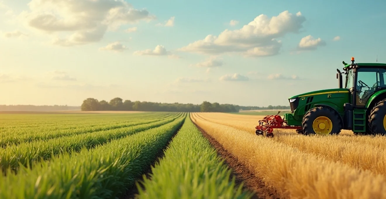
Satellite-based farm equipment navigation systems
The backbone of GPS technology in agriculture is the network of satellite-based navigation systems that provide precise positioning information to farm equipment. These systems have revolutionized the way farmers operate their machinery, offering unparalleled accuracy and efficiency in field operations.
RTK (Real-Time kinematic) GPS for centimeter-level accuracy
RTK GPS technology represents the pinnacle of precision in agricultural navigation systems. By using a network of fixed ground-based reference stations, RTK GPS can provide centimeter-level accuracy in real-time. This level of precision is crucial for applications such as planting row crops, installing drainage tiles, and land leveling.
Farmers using RTK GPS systems can achieve pass-to-pass accuracy of less than 2.5 cm, allowing for extremely precise placement of seeds and nutrients. This precision not only improves crop yields but also reduces input costs by minimizing overlap and skips during field operations.
WAAS (wide area augmentation system) for enhanced positioning
WAAS is a satellite-based augmentation system that enhances the accuracy and reliability of GPS signals across North America. For farmers who don’t require the centimeter-level accuracy of RTK, WAAS provides a cost-effective alternative with sub-meter accuracy.
WAAS-enabled GPS receivers can achieve accuracies of 3-5 meters, which is sufficient for many agricultural applications such as yield mapping, soil sampling, and variable rate application of fertilizers and pesticides. The system’s wide coverage area and free service make it an attractive option for many farmers.
Differential GPS (DGPS) in variable rate applications
Differential GPS (DGPS) is another technique used to improve the accuracy of GPS in agricultural applications. DGPS uses a network of fixed, ground-based reference stations to broadcast the difference between the positions indicated by the satellite systems and the known fixed positions.
In variable rate applications, DGPS allows for precise control over the application of inputs such as fertilizers and pesticides. By combining DGPS data with soil maps and crop health information, farmers can apply inputs at varying rates across their fields, optimizing resource use and potentially increasing yields.
Multi-constellation GNSS integration for improved coverage
Modern agricultural GPS systems often integrate multiple Global Navigation Satellite Systems (GNSS) constellations, including GPS, GLONASS, Galileo, and BeiDou. This multi-constellation approach provides improved coverage and reliability, especially in challenging environments such as areas with dense tree canopies or steep terrain.
By leveraging signals from multiple satellite systems, farmers can maintain high-precision positioning even when the view of the sky is partially obstructed. This integration ensures consistent performance across a wide range of field conditions and geographical locations.
Automated tractor steering and field operations
One of the most visible and impactful applications of GPS in agriculture is automated tractor steering. This technology allows tractors and other farm equipment to navigate fields with minimal human intervention, dramatically improving efficiency and reducing operator fatigue.
John Deere AutoTrac™ system for Hands-Free guidance
The John Deere AutoTrac™ system is a prime example of GPS-guided automated steering technology. This system uses RTK GPS signals to provide hands-free guidance for tractors and other self-propelled equipment. AutoTrac™ can maintain straight or curved lines with centimeter-level accuracy, allowing operators to focus on other aspects of field operations.
Benefits of the AutoTrac™ system include reduced overlap and skips, increased field efficiency, and the ability to operate effectively in low-visibility conditions such as dust, fog, or darkness. The system can also help reduce operator fatigue, potentially leading to longer working hours and increased productivity.
Trimble EZ-Pilot® pro for retrofit autosteer solutions
For farmers looking to add automated steering capabilities to their existing equipment, the Trimble EZ-Pilot® Pro system offers a flexible retrofit solution. This system uses GPS guidance to control the steering wheel, allowing for hands-free operation of a wide range of agricultural vehicles.
The EZ-Pilot® Pro can be easily transferred between different vehicles, making it a cost-effective option for farmers with multiple pieces of equipment. The system’s high-torque motor provides accurate steering even on rough terrain or with difficult soil conditions.
Case IH AFS AccuGuide™ for precise row cultivation
The Case IH AFS AccuGuide™ system is designed to provide precise guidance for row crop cultivation and other field operations that require high accuracy. Using RTK GPS technology, AccuGuide™ can maintain sub-inch accuracy, allowing for precise control of implements for tasks such as planting, spraying, and harvesting.
One of the key advantages of the AccuGuide™ system is its ability to maintain accuracy even on sloping or contoured fields. This capability ensures consistent performance across a wide range of field conditions, helping farmers maximize productivity and minimize waste.
Topcon X35 Console for integrated precision control
The Topcon X35 Console represents an advanced integrated solution for precision agriculture. This system combines GPS guidance with implement control, allowing farmers to manage multiple aspects of their field operations from a single interface.
Features of the X35 Console include auto-steering, variable rate control, section control for sprayers and planters, and advanced data management capabilities. By integrating these functions into a single system, the X35 Console helps streamline field operations and improve overall farm efficiency.
GPS-enabled yield mapping and crop monitoring
GPS technology has revolutionized the way farmers monitor and analyze crop yields. Yield mapping, enabled by GPS-equipped combine harvesters, allows farmers to create detailed maps of crop productivity across their fields. These maps provide valuable insights into field variability and help inform future management decisions.
The process of yield mapping involves collecting data on crop yield and moisture content as the combine moves through the field. GPS technology provides precise location data for each measurement, allowing the creation of high-resolution yield maps. These maps can reveal patterns of productivity influenced by factors such as soil type, topography, and management practices.
In addition to yield mapping, GPS technology enables more precise crop monitoring throughout the growing season. GPS-equipped drones and satellites can capture high-resolution imagery of fields, providing farmers with valuable data on crop health, pest infestations, and nutrient deficiencies. This information allows for targeted interventions and more efficient use of resources.
GPS-enabled yield mapping and crop monitoring have transformed farm management from reactive to proactive, allowing farmers to address issues before they impact yield.
Geospatial data analysis for agricultural decision-making
The vast amount of geospatial data generated by GPS-enabled farm equipment and monitoring systems requires sophisticated analysis tools to derive actionable insights. Geographic Information Systems (GIS) and other geospatial analysis software play a crucial role in helping farmers make sense of this data.
ArcGIS for agriculture: spatial pattern recognition
ArcGIS, a powerful GIS software suite, offers specialized tools for agricultural applications. One of its key capabilities is spatial pattern recognition, which can help farmers identify trends and relationships in their field data. By analyzing patterns in yield maps, soil samples, and other geospatial data, farmers can gain insights into the factors influencing crop performance.
ArcGIS also enables the creation of prescription maps for variable rate applications. These maps combine multiple layers of data to determine the optimal application rates for inputs such as fertilizers and pesticides across different areas of a field.
QGIS for open-source farm management solutions
QGIS is a popular open-source GIS software that provides a cost-effective solution for farm data management and analysis. Its extensive plugin ecosystem includes tools specifically designed for agricultural applications, such as yield map creation and analysis.
One of the advantages of QGIS is its flexibility and customizability. Farmers and agricultural consultants can develop custom plugins and scripts to address specific needs, making it a versatile tool for a wide range of farm management tasks.
R statistical software for crop yield prediction models
R is a powerful statistical programming language that is increasingly being used in agricultural data analysis. Its extensive libraries for spatial data analysis and machine learning make it well-suited for developing crop yield prediction models based on GPS-derived data.
Using R, researchers and agronomists can develop sophisticated models that incorporate multiple variables such as weather data, soil characteristics, and management practices to predict crop yields. These models can help farmers make informed decisions about planting dates, input applications, and harvest timing.
Python geospatial libraries for custom ag-tech development
Python, with its rich ecosystem of geospatial libraries such as GeoPandas and Rasterio, is becoming increasingly popular for custom agricultural technology development. These libraries allow developers to create tailored solutions for processing and analyzing GPS-derived agricultural data.
Applications of Python in agricultural geospatial analysis include automating the processing of satellite imagery, developing custom algorithms for yield map analysis, and creating web-based tools for visualizing farm data. The flexibility and extensive libraries of Python make it a valuable tool for innovative ag-tech solutions.
Integration of GPS with IoT and AI in smart farming
The integration of GPS technology with the Internet of Things (IoT) and Artificial Intelligence (AI) is ushering in a new era of smart farming. This convergence of technologies is enabling unprecedented levels of automation and data-driven decision-making in agriculture.
IoT sensors equipped with GPS capabilities can provide real-time data on soil moisture, temperature, and nutrient levels across a field. This data, when combined with GPS-tagged information from farm equipment, can create a comprehensive picture of field conditions and crop performance.
AI algorithms can analyze this wealth of GPS-tagged data to identify patterns and make predictions. For example, machine learning models can use historical yield data, weather information, and current field conditions to predict crop yields and suggest optimal management strategies. These AI-powered insights can help farmers make more informed decisions about planting, irrigation, and harvesting.
The combination of GPS, IoT, and AI is also enabling the development of autonomous farm equipment. Self-driving tractors and drones can use GPS for navigation while leveraging AI to make real-time decisions based on sensor data. This level of automation has the potential to significantly increase farm efficiency and productivity.
As these technologies continue to evolve and integrate, the future of farming looks increasingly data-driven and precision-oriented. GPS technology, serving as the foundation for precise location data, will remain at the heart of these advancements, continuing to revolutionize modern farming practices.